Today I decided to try and link up two separate old logging roads in the Mt. Garfield area. The first road, of which I am very familiar, is the access road to the Littleton town water supply on the east branch of the Gale River. On the opposite side of the stream and bit off to the west is a series of partially overgrown logging roads that appear to have been in heavy use several years ago.
Both roads are blocked to public vehicular traffic (though that can be easily overcome if need be). If I were able to connect these two roads into a single loop it can make cross-country scouting in that area much easier be it on foot, mountain bicycle, or motorized vehicle.
Parking along the Gale River loop road near the Mt. Garfield (elevation ) trailhead, I slunk off into the thick forest cover to a concealed position on the hillside where I could still see my truck and quietly waited for ten minutes. In future posts I will discuss the many reasons this pause in the initial minutes of a scout is so very important.
At the end of my ten-minute initiation period I then set a trip wire along my track composed of a simple fine cotton line tied between two twigs. Should someone be tracking me, there is a chance they will break this line and even if they should be cognizant of having done that there would be little they could do to hide the fact.
Upon reaching the start of the old logging road, which in many place is still in excellent shape and driveable by truck, I took a few minutes to carefully observe the ground for tracks.
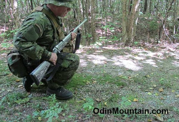
When first starting a scout it is important to learn as much as possible about who or what has been traveling along your intended route. Humans of course will be of prime concern, and I will want to know the mode of travel they have been using.
For example, these roads are gated to public use so there is a good chance if I find truck tire tracks it has something to do with official business such as US Forest Personnel or Town employees inspecting the reservoir. However, it is best not to jump to conclusions since likely explanations are not always correct: there are the occasional search and rescue operations, people have been known to bypass the gates unauthorized, and sometimes the military is in the White Mountains area.
It also pays to carefully observe for tracks of wildlife that has recently been in the area. Here in the Great North Woods I am likely to encounter moose, black bear, whitetail deer, coyote, turkey, and a number of other species that can be of significance for a variety of reasons. Moose especially can be problematic due to their unpredictable behavior when unexpectedly come upon so I am always sure to be as aware as possible to their presence.
Just about any species of wildlife can be a player during a scout – everything from early warning (a squirrel chattering can alert you to an enemy or alert an enemy to you), a partridge suddenly bursting forth into noisy flight through the underbrush, noisy insects suddenly stopping their infernal racket, or even a rabbit suddenly running past you.
In places the old logging road is fast becomming overgrown through disuse. Pioneer species including various species of weeds and grasses, ferns, raspberries and blackberries etc. are quick to exploit the areas of open light in an otherwise thick forest canopy. Be sure to check for recently bent vegetation as it would be impossible to walking through this without leaving a trace.
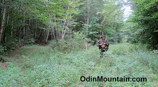
While it can be risky to walk these open pathways for a variety of reasons, factors such as time and ease of travel come into play. As always, it’s a judgement call. Walking through the dense jungle-like forest is much slower, more noisy, more prone to injury, and you have to keep some of your mental resources concentrated on direction of movement so you do not go off-course. Walking an obvious pathway invites ambush, booby-traps, and unexpected meetings with people.
Perhaps a mile or or so into the scout, I noticed this patch of very bright yellow that shone through small openings in the thickly vegetated forest floor. About 125-feet away, it looked potentially suspicious and if I didn’t check it out I would always wonder. No amount of moving about and squinting through tiny openings could reveal exactly what it was I was seeing.
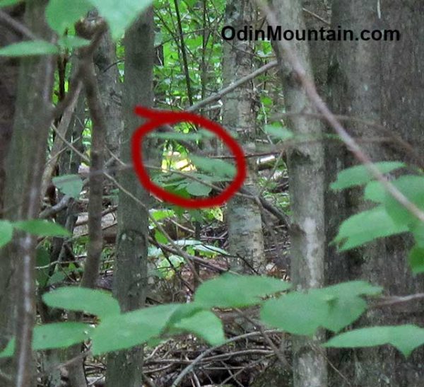
To take this picture I zoomed in to the cameras maximum magnification. While some forest leaves during the Fall season can be this bright yellow, and sometimes distressed trees during any time of the year, it is also a popular tent color. Since here was an anomaly I decided to investigate.
Carefully and slowly circling around at about 50 yards from the yellow splotch (which is a fair distance in thick forest growth) I gradually worked my way to the spot and discovered that the yellow color was indeed the leaves of a fallen over Moose Maple tree.
The thin yellow leaves seem to magnify the sunlight and almost glow in the relative darkness under the thick forest canopy.
At the base of a hill where two old logging roads intersected and next to a large boulder, I came upon the wreckage of an All Terrain Vehicle, part of which appeared to be burned or melted.
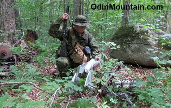
I conjecture the ATV may have been coming down the hill at a high rate of speed, lost control, and slammed into the boulder in a spectacular accident.
Whatever the cause of the wreckage, this brings to light the fact that casualties caused by accident are often higher than those caused by the opposition. This is important and will be the subject of another post.
I often broke spider webs strung across the road, tickling my face and rather pesky. However this gave me a vital piece of information: nobody had been walking along the road for at least several hours or they would have already broken the webs.
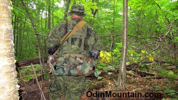
I paused at and marked a particularly well-placed spider web that extended across the road as a natural trip line that I could inspect should I choose to come back the same way. The web is so thin it is not visible in the picture. Note how a patch of sunlight is reflecting off my rifle stock, something which I will have to soon amend.
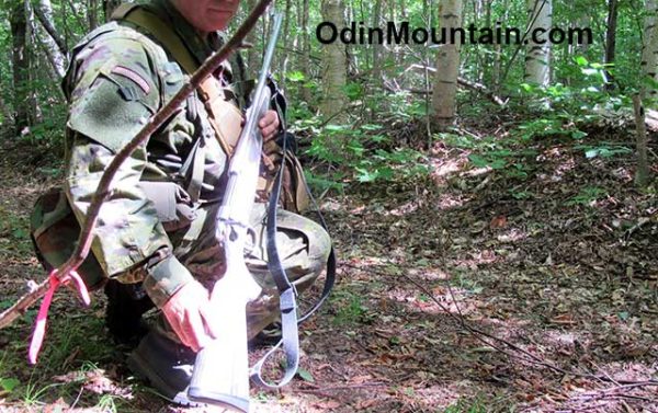
It is my experience that natural detection devices can be readily used to advantage.
At this intersection of roads I chose the left, as it’s general direction is East which I knew was the direction of the resevoir. In a short while I came upon large heavy equipment tracks such as those left by a bulldozer or bucket loader. This induced me to think I was on the right road as this piece of heavy equipment may have been used in work on the dam though it may also be that of a logger.
Judging from the degradaton of the spoor left by the heavy tracked vehicle, it had passed through during the Spring season. As I continued roughly east, I came upon four or five bridges made for snowmobiles that could not support the weight of the large machine. These bridges across small streams were caved in.
This serves as an example where tanks and other heavy equipment are not well-suited to off-road travel in the forests and mountains. In fact, if they are not careful they can trap themselves.
Further along the logging road became quite wet, muddy, and less of a road. Still following the tracked vehicle spoor and string of broken bridges, I eventually came upon the resevoir and the ice cold mountain stream that serves it.

Here I used my water filter to obtain a long refreshing drink. It was evident the tracked vehicle was used to remove debris that had accumulated in the retention pond, there being a large pile of wooden sticks and gravel off to the side.
From this point on the Reservoir I continued on down the familiar logging road that runs along the east side of the stream. I noted there used to be a bridge here, now gone, perhaps washed out during Hurricane Katrina some years ago. This would explain why the tracked vehicle had to accesses the west side of the dam using the logging road I walked up on, inadvertently destroying the snowmobile bridges.